Phnom Penh City Bus

Phnom Penh City Bus
September 5, 2024
Articles
Description
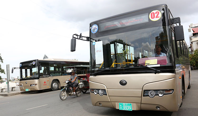
Phnom Penh City Bus is a municipal public transport system that serves Phnom Penh, the capital of Cambodia. The system opened to the public in September 2014 with 3 lines, other lines have been gradually added over the next several years, as of 2018, 11 lines run throughout the city. The system covers Prek Pnov (North), Ta Khmao (South), Chbar Ampov (East), and Special Economic Zone (West), there are plans to stretch the network outward.
The fare for the public buses is KHR1,500 (USD0.37) per voyage irrespective of distance. Only local currency Riel is accepted. Senior citizens (age over 70), small children (under 1 meter), disabled, monks, teachers, students, factory workers (until September 2019) travel free as of 2018, though you must confirm your identity by wearing your student card, teacher card or working card before boarding.
The bus starts daily from 05:30 in the morning until 20:30 at night.
City Bus Lines and Stops
Due to increase of cars and motorcycles (about 300,000 cars and 1,000,000 motorcycles in Phnom Penh today), City Hall has launched three bus lines. The bus is a more sustainable form of transport for the city because it reduces traffic accidents, congestion, and environmental pollution.
Line 01
Line 01 travels from Kilometer 9 Terminal, going south on National Road 5, circling Old Stadium Roundabout, traveling south alongside Monivong Boulevard (National Highway 1), passing Chbar Ampov Market, cuts across Kbal Thnal Stop, crosses Monivong Bridge, and ends at Boeung Chhouk Terminal.
Line 01 is one of the busiest line because it connect Phnom Penh to Cbar Ampov. Route Map
Line 02
Line 02 begins from Aeon Mall 2 Terminal, going east on Oknha Mong Reththy Street (1928), cuts across Camko City Stop, around TVK Station, traveling east on Street 70, circling Old Stadium Roundabout, turns right on street 47, moving around Wat Phnom, going south of Norodom Boulevard (National Road 2), going around Independent Monument, crosses Kbal Thnal Sky Bridge, and arrives at Ta Khmao the capital of Kandal Province.
Line 02 is one of the busiest line because it connect Phnom Penh to Ta Khmao. Route Map
Line 03
Line 03 starts from Russey Keo Park Terminal, going south on National Road 5, circling Old Stadium Roundabout, going around Wat Phnom, moving south on Norodom Boulevard (National Road 2), around Central Market, traveling west alongside Kampuchea Krom Boulevard, crosses 7 Makara Sky Bridge, going west on Russian Federation Bouelevard, around Chaoum Chaou Circle Garden, moving south on National Road 3, and stops at Borey Santepheap 2 Terminal.
Line 03 is one of the busiest line. Route Map
Line 4A
Line 4A starts from Russey Keo Park Terminal, going south on National Road 5, circling Old Stadium Roundabout, going around Wat Phnom, moving south on Norodom Boulevard (National Road 2), around Central Market, traveling southwest alongside Charles de Gaulle Street (217), crosses Kong Hing Stop, cuts across Olympic Water Reservoir Stop, going southwest alongside Monireth Boulevard (217), crossing Steung Mean Chey Sky Bridge, moving west on Veng Sreng Boulevard. turns left at Canadia Water Reservoir Stop, passing Toul Pongror Market, and stops at Borey Santepheap 2 Terminal.
Line 4A is one of the busiest line because it lies on the factory zones which many factory workers use the city bus to go to work and return home. Route Map
Line 4B
Line 4B starts from Russey Keo Park Terminal, going south onNational Road 5, circling Old Stadium Roundabout, going around Wat Phnom, moving south on Norodom Boulevard (National Road 2), around Central Market, traveling southwest alongside Charles de Gaulle Street (217), crosses Kong Hing Stop, cuts across Olympic Water Reservoir Stop, going southwest alongside Monireth Boulevard (217), crossing Steung Mean Chey Sky Bridge, moving west on Veng Sreng Boulevard, going around Chaom Chau Circle Garden, travelling west on National Road 4, and ends at Special Economic Zone Terminal.
Line 4B is one of the busiest line because it lies on the factory zones which many factory workers use the city bus to go to work and return home. Route Map
Line 05
Line 05 begins from Aeon Mall 2 Terminal, moving south of 1003 street, turns left to Road 1966, going left to Road 598, turning right to Road 337, turns right to Road 566, travelling south on Samdach Pen Nouth Street (289), going under Techno Sky Bridge, moving south passing Doeurm Kor Market then east alongside Mao Tse toung Boulevard (245), cuts across Bokor Stop, going north on Samdach Sothearos Boulevard (3), and arrives at Aeon Mall 1 Terminal.
Line 05 is usually busy around evening period and Sunday due to people going to Aeon Malls. Route Map
Line 06
Line 06 travels from Borey Rung Roeung Terminal, moving south alongside National Road 6, crossing Chroy Changvar Bridge, circling Old Stadium Roundabout, going west on Street 70, around TVK Station, cuts across Camko City Stop, travelling west on Oknha Mong Reththy Street (1928), turns left to Oknha Try Heng Street (2011), moving east on Russian Federation Boulevard, and terminates at Century Plaza Market terminal. Route Map
Line 7A
Line 7A leaves from Kilometer 9 Terminal, moving north on National Road 5, travelling south alongside Chea Sophara Street (598), going under 7 Makara Sky Bridge, moving south on Yothapol Khemarak Phoumin Boulevard (271), turns left to Oknha Tep Phan Street (182) passes Depo Market, crosses Kong Hing Stop, passing Orussey Market, turns right to Monivong Boulevard (National Highway 1), turns right to Preah Sihanouk Boulevard (274), going around Independent Monument, turns right to Norodom Boulevard (National Highway 2), turns left to Oknha Chrun You Hak Street (294), moving south of Samdach Sothearos Boulevard (3), and arrives at Aeon Mall 1 terminal. Route Map
Line 7B
Line 7B leaves from Kilometer 9 Terminal, moving north on National Road 5, travelling south alongside Chea Sophara Street (598), going under 7 Makara Sky Bridge, moving south on Yothapol Khemarak Phoumin Boulevard (271), crosses Steung Mean Chey Sky Bridge, cuts across Kbal Thnal Stop, crosses Monivong Bridge, and stops at Chbar Ampov Terminal. Route Map
Line 08
Line 08 starts from Kilometer 9 Terminal, going north on National Road 5, crosses Prek Pnov Bridge, moving alongside Ly Yongphat Street, travelling south on National Road 6, and ends at Borey Rung Roeung Terminal. Route Map
Line 09
Line 09 begins from Borey Santepheap 2 Terminal, moving south on National Road 3, reaches Vattanac Industrial Park 2 then makes a U-turn, turns left to Prateah Lang Street, and stops at Special Economic Zone Terminal. Route Map
Line 10
Line 10 begins from Century Plaza Terminal and stops at Beung Chhouk Terminal. Route Map
Line 11
Line 11 begins from Wat Sleng Terminal and stops at Steung Meanchey Terminal. Route Map
Line 12
Line 12 begins from Royal Railway Station to Royal Railway Station. Route Map
Line 13
Line 13 begins from French Embassy Terminal and stops at Roundabout Phsar Deum Thakov Terminal. Route Map


